
| Accommodation | Activities | Arts and Crafts | Attractions | Dining | History |
| Home | Location | Recreation | Visitor Info | Wineries | Within Reach |
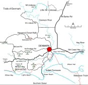
Around Denmark, on The Rainbow Coast as the southern part of the state is referred to, are many walks. Several are close to the town centre while others are in forest reserves or along the coastal parks.
Our weather is ideal for walking. In summer the temperate conditions see warm days but not as hot as Perth. Early morning and afternoon walking conditions are the best.
Walks close to town cover some varied and interesting parts of Denmark. They are flat and can be short or long depending on what you want.
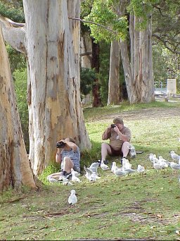
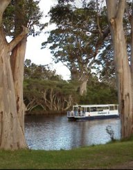 | Mokare Riverside Trail This mainly concrete, 3 km path, has several starting points. You can commence at the riverside Berridge Park near the traffic bridge. Follow the gentle contours downstream to the old railway bridge. Before you cross the railway bridge you might like to cross the road to the old railway station site. Here you will find a photographic display on the verandah of the old Post Office as well as the turntable and other railway memorabilia. Look out for the wide variety of birds as well as trees and shrubs along this aquatic 'highway'. | ||||
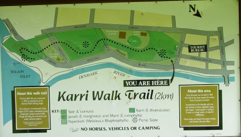
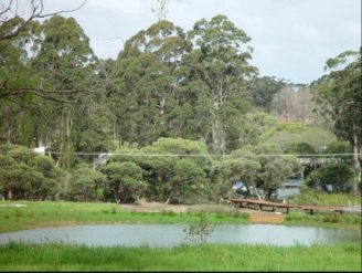 | Community Park Upstream of the traffic bridge Thornton Park has a wooden walkway across a small wetland. This is an entrance to the parklands being developed on the State Dairy Farm site. There already exist several linked paths leading to a pedestrian footbridge that gives access to the Denmark High School. This is on the Albany side of the town. From the High School you can walk back either on the pedestrian path or follow, part of the way, the old Millars railway embankment | ||||
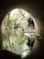 | Wilson Inlet heritage Walk From the old railway bridge near the mouth of the Denmark River is a track following the old railway line. The line, built in the 1920's, follows the shores of the Wilson Inlet. It will take you 6 km, on a flat path, to Rudyard, east of the town Along the way are several huts with information on aboriginal occupation, flora and fauna. You can also walk down to the bottom of an embankment to look at one of the three large culverts built along this line. Locally referred to as a 'tunnel' it has a stream flowing through it and into the inlet. | ||||
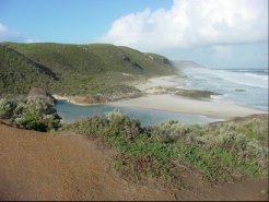
The Bibbulmun Track traverses 964km from Kalamunda to Albany. At Denmark it is readily accessible for a few hours, half day or day walks. You could even camp overnight at one of the approved staging points. You can choose from coastal heath and cliff tops, karri forests or inlet edges. Climb to the tops of prominent hills for outstanding views if you want a great experience. Make it as long or short, as easy or difficult as you want. It is up to you. You don't have to travel far as part of the track comes close to town at the Rivermouth near the old railway bridge. Other sections can be easily reached by car. |
 | ||||
 |
Just to the south west of town is Mt Hallowell. The Bibbulmun track traverses this prominent hill giving views of the coast and surrounding farmland. You can climb to 'Monkey Rock' for these views. Access is from the eastern end (- Ocean Beach Rd) OR south-west (from Lights Rd). Climbs are steep in parts. Please remember to take extra care on wet rocks. | ||||
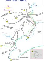
MAP: Walks close to town |
MAP: Walks away from town |
Travelling through some of the National Parks is the Bibbulmun Track. Named after an aboriginal tribe of the south west this walking trail offers short, half day, day and longer walks along scenic, specially chosen tracks. Some sections go through forests, some over coastal dunes, along old railway tracks and up prominent hills. The really adventurous undertake the nearly 1000km journey from Kalamunda to Albany along the full length of the trail.

'Friends of the Bibbulumun's' comprehensive site
| Accommodation | Activities | Arts and Crafts | Attractions | Dining | History |
| Home | Location | Recreation | Visitor Info | Wineries | Within Reach |